Zip Code Boundaries Data - Data Layout#
Introduction#
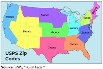
ZIP Code Boundaries represents five-digit ZIP Code areas used by the U.S. Postal Service (USPS) to o assist in the efficient sorting and routing of mail. The first digit of a five-digit ZIP Code divides the United States into 10 large groups of states (or equivalent areas) numbered from 0 in the Northeast to 9 in the far West.
Within these areas, each state is divided into smaller geographical areas, identified by the second and third digits. These digits, in conjunction with the first digit, represent a Sectional Center Facility (SCF) or a mail processing facility area. The fourth and fifth digits identify a post office, station, branch or local delivery area.
Sample File#
Click here to download the sample file.
Layout and Definitions#
Grouping |
Column Name |
Type |
Definition |
|---|---|---|---|
Address |
ZIPCode |
nvarchar(5) |
ZIP Code |
Geo |
Shape |
geography |
Internal shape information used to generate shape |
CenterLatitude |
decimal(18,6) |
The latitude in decimal degrees using the WGS84 datum for the centroid of the parcel |
|
CenterLongitude |
decimal(18,6) |
The longitude in decimal degrees using the WGS84 datum for the centroid of the parcel |